Flat Earth Maps
+56
swentz101
RileySlowWave
defrank
suepinehillfarm
Nym
Universe
Emperor's New Clothes
tycho_brahe
Bicenie
Libertarian
Realearth
Freepressfreepeople
superuserdo
MMDC
mindflood
Jacois
SkipSullivan
Oliver_Bestfall
Truth of Reality
TheFreedomMinistry
Niar_Azeroth
MaryMoon
siriusrising777
HafizAbdulWahhab
N0curve
Torus_Ouroboros
Admin
ZeusThunderer
RickFE
Artemis
Wertikal
Saltwater42
Bertrand29
thugnastylol
Tiwar
Skywalker
FL@T-E@RTH
inerratic
putontheglassesagain
ebcih
VeroSercanto
ABalancedKarma
_Madison
mitch
riggie11
anko
csp
Schpankme
Themis
susie
FlatEartherInNH
vortexpuppy
Shad01
lizardking
TravelinHero
Thinkforyourself
60 posters
IFERS - Exposing the 'Global' Conspiracy From Atlantis to Zion :: Reference Materials, eBooks, Articles, Videos, Maps
Page 6 of 9
Page 6 of 9 •  1, 2, 3, 4, 5, 6, 7, 8, 9
 Re: Flat Earth Maps
Lol, north and south seas. Would be more logical if they were stacked north / south, but they seem to just be two whole bodies of water here. Not saying that makes it bogus, but doesn't seem very useful of naming.
thugnastylol- Posts : 39
Points : 3101
Reputation : 39
Join date : 2016-08-13
Location : California
 Re: Flat Earth Maps
I have looked at a bunch of maps from books and online sources. One peaked my interest the most and I looked into it a lot more than the others.
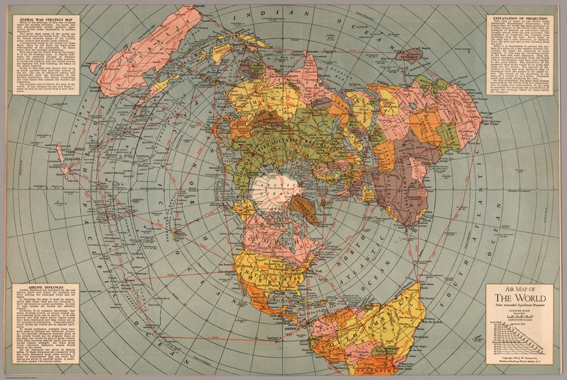
I looked into the distances and paths for the flights. The distances and paths match up on google earth which is odd to say the least. It is also different from the one the poster boys use which has Australia more towards the east. A lot of navigation maps have to be accurate so I thought I would look into this map more. I am not saying this is the correct map, what I am saying is the data they put on it is very accurate as to what they claim the distances are on a globe. No greater circles either....What I find the most curious about such a detailed map, is why so much detail. You can zoom in to read the fine print of all the little islands. If they claim it is just a visual aid, why go into that amount of detail? I am looking into getting a paper copy to see if the trigonometry for the distances is right. Only with a scale map can I get the proper scale to measure it out. But as far as the distances they claim, it is what google earth claims too....The map even shows the scale at which the longitudes spread out....Why would that matter if it wasn't accurate? Now every map ever made is purposely distorted. We all know this, and it is acknowledged as being the fault of a globe being laid flat. So the shape and size of the continents might not be right, but the distances and general directions of the flights on this map seem dead on. I think we need to get some type of map started to at least have a rough model. Some of the cities and their locations can be verified using longitudes. It is admitted by geography that the longitudes are correct. They just say the latitudes are not accurate. If they start to get out of whack, we know the map isn't right. Using flight times is really a bad method. Airplanes ride on jet streams that can make the flight way faster or slower. This is the method most use to claim a map as false. When in fact they are using the improper in flight speed to determine this fact. Saying a plane flies at 540mph, when it can reach almost 900 on a Jetstream, is not logical or empirical. If they had a video of the entire flight showing its speed, then it might hold a little more weight. I just think they spend so much time pointing at one map and saying it is wrong and keep looking at this one.....that maybe we need to look at the ones they are not showing.

I looked into the distances and paths for the flights. The distances and paths match up on google earth which is odd to say the least. It is also different from the one the poster boys use which has Australia more towards the east. A lot of navigation maps have to be accurate so I thought I would look into this map more. I am not saying this is the correct map, what I am saying is the data they put on it is very accurate as to what they claim the distances are on a globe. No greater circles either....What I find the most curious about such a detailed map, is why so much detail. You can zoom in to read the fine print of all the little islands. If they claim it is just a visual aid, why go into that amount of detail? I am looking into getting a paper copy to see if the trigonometry for the distances is right. Only with a scale map can I get the proper scale to measure it out. But as far as the distances they claim, it is what google earth claims too....The map even shows the scale at which the longitudes spread out....Why would that matter if it wasn't accurate? Now every map ever made is purposely distorted. We all know this, and it is acknowledged as being the fault of a globe being laid flat. So the shape and size of the continents might not be right, but the distances and general directions of the flights on this map seem dead on. I think we need to get some type of map started to at least have a rough model. Some of the cities and their locations can be verified using longitudes. It is admitted by geography that the longitudes are correct. They just say the latitudes are not accurate. If they start to get out of whack, we know the map isn't right. Using flight times is really a bad method. Airplanes ride on jet streams that can make the flight way faster or slower. This is the method most use to claim a map as false. When in fact they are using the improper in flight speed to determine this fact. Saying a plane flies at 540mph, when it can reach almost 900 on a Jetstream, is not logical or empirical. If they had a video of the entire flight showing its speed, then it might hold a little more weight. I just think they spend so much time pointing at one map and saying it is wrong and keep looking at this one.....that maybe we need to look at the ones they are not showing.

RickFE- Posts : 71
Points : 3000
Reputation : 118
Join date : 2017-03-23
Age : 67
Location : Ontario Canada
 Re: Flat Earth Maps
RickFE wrote:
every map ever made is purposely distorted
the shape and size of the continents might not be right
The Globe Continents are distorted because they first convert the Gleason type Flat Earth Map, to the Mercator Projection, to Globe.
Tutorial - convert Flat Earth Map to Mercator to Globe

Schpankme- Posts : 1202
Points : 6083
Reputation : 1606
Join date : 2015-12-30
 Re: Flat Earth Maps

Here's a high resolution version of this map:
http://zeus-thunderer.deviantart.com/art/Flat-Earth-Map-Countries-672263428
.
ZeusThunderer- Posts : 9
Points : 2835
Reputation : 7
Join date : 2017-03-11
 Re: Flat Earth Maps
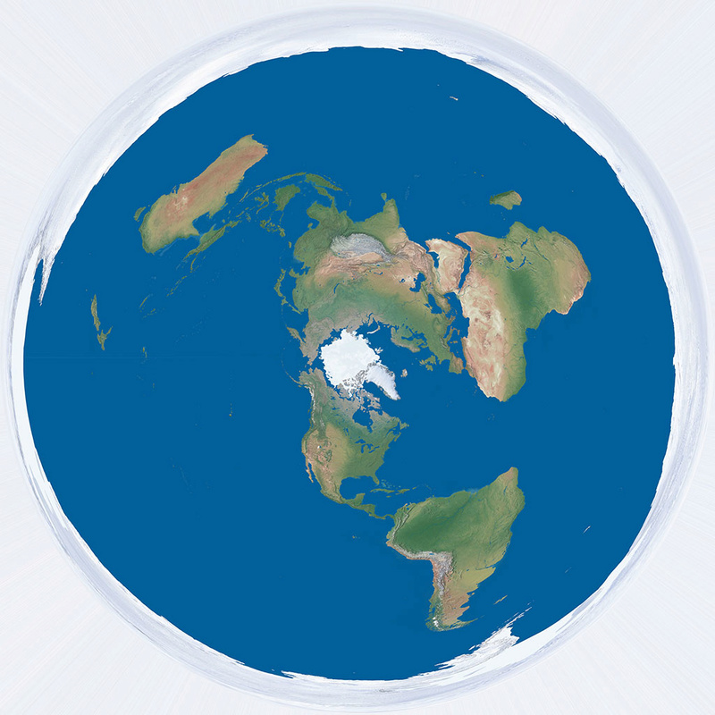
Here's a high resolution version of this map:
http://zeus-thunderer.deviantart.com/art/Flat-Earth-Map-672718405
.
ZeusThunderer- Posts : 9
Points : 2835
Reputation : 7
Join date : 2017-03-11
 Re: Flat Earth Maps
ZeusThunderer wrote:
Here's a high resolution version of this map:
This image looks to have a Convex surface or Lens effect, is this true?

Schpankme- Posts : 1202
Points : 6083
Reputation : 1606
Join date : 2015-12-30
 Re: Flat Earth Maps
Schpankme wrote:ZeusThunderer wrote:
Here's a high resolution version of this map:
This image looks to have a Convex surface or Lens effect, is this true?
Yes, it certainly does have "bulge" to it, I noticed as well - probably not the best example.

csp- Posts : 424
Points : 4729
Reputation : 1054
Join date : 2016-01-04
Location : Australia
 Re: Flat Earth Maps
Schpankme wrote:ZeusThunderer wrote:
Here's a high resolution version of this map:
This image looks to have a Convex surface or Lens effect, is this true?
Yes both maps have been made using Photoshop's Distort -> Polar Coordinates filter.
It's the only way to make a Gleason Flat Earth Map, unless you draw by hand.
They are both very accurate and overlay over the Gleason map.
ZeusThunderer- Posts : 9
Points : 2835
Reputation : 7
Join date : 2017-03-11
 Re: Flat Earth Maps
csp wrote:Schpankme wrote:ZeusThunderer wrote:
Here's a high resolution version of this map:
This image looks to have a Convex surface or Lens effect, is this true?
Yes, it certainly does have "bulge" to it, I noticed as well - probably not the best example.
The only bulge here is in my pants! Actually you are correct,
the text of each Country had to be distorted.
ZeusThunderer- Posts : 9
Points : 2835
Reputation : 7
Join date : 2017-03-11
 Re: Flat Earth Maps
ZeusThunderer wrote:
maps have been made using Photoshop's Distort -> Polar Coordinates filter
I'm not interested in a distorted flat Earth Maps that looks like someone is promoting Dome or Curvature.
Please see: Air Map of the World

Schpankme- Posts : 1202
Points : 6083
Reputation : 1606
Join date : 2015-12-30
 Re: Flat Earth Maps

Here's an Ultra High Resolution version (6485 x 8900 pixels)
http://zeus-thunderer.deviantart.com/art/Hammond-s-Air-Age-Map-of-the-World-672873875
.
ZeusThunderer- Posts : 9
Points : 2835
Reputation : 7
Join date : 2017-03-11
 Re: Flat Earth Maps
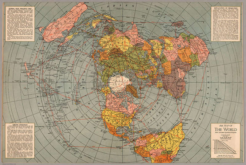
Here's a High Resolution version (5086 x 3411 pixels)
http://zeus-thunderer.deviantart.com/art/Air-Map-of-the-World-1943-672877707
.
ZeusThunderer- Posts : 9
Points : 2835
Reputation : 7
Join date : 2017-03-11
 Re: Flat Earth Maps
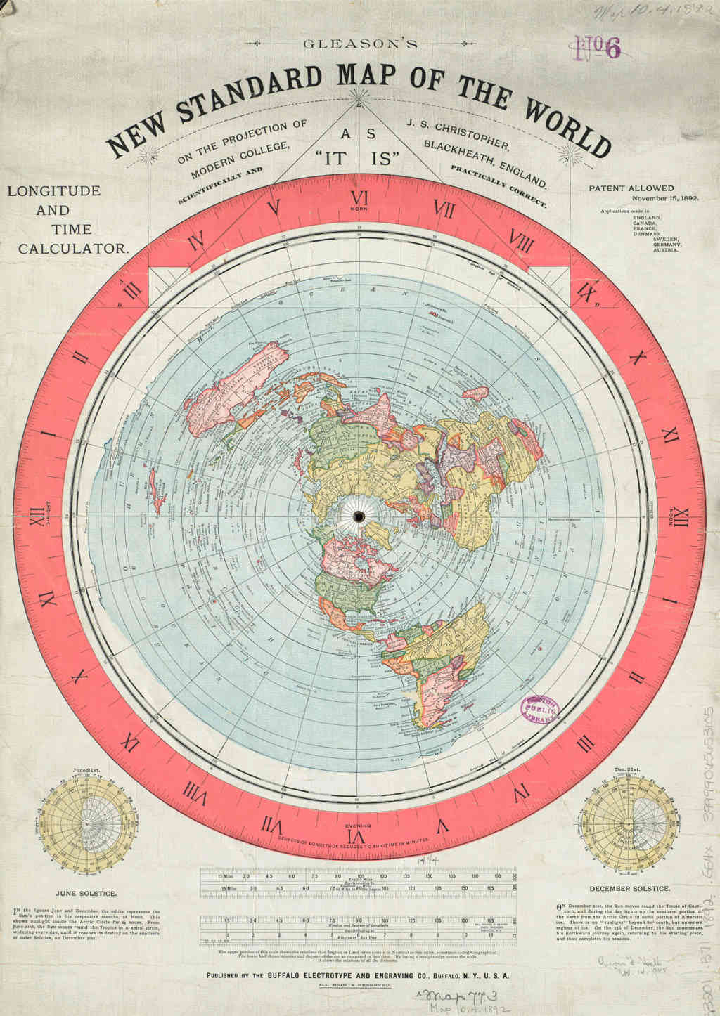
Here's a High Resolution version of this map (4641 x 6554 pixels)
http://zeus-thunderer.deviantart.com/art/Gleason-s-Flat-Earth-Map-672880072
.
ZeusThunderer- Posts : 9
Points : 2835
Reputation : 7
Join date : 2017-03-11
 Re: Flat Earth Maps
Atlantic Telegraph Tech Drawing showing the profile of the Atlantic seabed which is level for 1665 miles.


 Re: Flat Earth Maps
Seen this flat earth map while watching the movie "Belly" with a friend earlier and had to take a screenshot. It's very similar to the UN Logo, but with a snake wrapped around it and the Chinese characters which say "World Snake" or "Planet of Snake." The movie is about 20 years old and they only flash this for a couple seconds but it caught my eye instantly.


Torus_Ouroboros- Posts : 34
Points : 2832
Reputation : 23
Join date : 2017-04-22
 Re: Flat Earth Maps
Torus_Ouroboros wrote:Seen this flat earth map while watching the movie "Belly"
Great find, hidden in plain sight as per usual.

csp- Posts : 424
Points : 4729
Reputation : 1054
Join date : 2016-01-04
Location : Australia
 Re: Flat Earth Maps
A few flat earth maps in this collection: "https://tpbclean.info/torrent/5939940/Old_Maps_Of_The_World.", uploading images seperately isn't working for me at the moment, sry!
N0curve- Posts : 1
Points : 2599
Reputation : 0
Join date : 2017-10-18
 Re: Flat Earth Maps
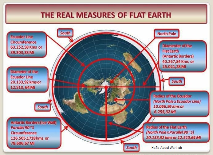
Here is some work done by a person who left it incompleted but i have completed it regarding Hammond's map
the Data has been verified by modern maps regarding distance between places.
In my point of view I have found the actual Earth size for flat earth model.
but i will look forward for feed backs in this regard
i named this project Hammond's map project 1 Nov.2017
for complete project album click below link:
https://photos.app.goo.gl/XcRhVDha6wWCRlqN2

 Re: Flat Earth Maps
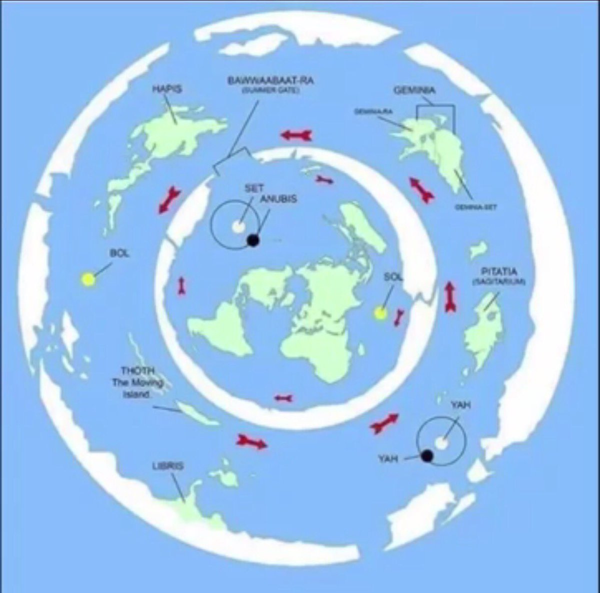
Please forgive me if this has been asked before. Can anyone tell me the origins of this flat earth map please?

siriusrising777- Posts : 7
Points : 2627
Reputation : 1
Join date : 2017-10-01
 Re: Flat Earth Maps
I cannot conclusively say, but the fact that map has (Annubis, Set & Yah) would indicate it to be of Egyptian origin.
Annubis is the Egyptian God of embalming and the afterlife and is the offspring of Set.
Set is the Egyptian God of disorder/violence who had an altercation with Horus (the God of the sky). He accompanied Ra to rebel Apep (who embodies chaos).
Yah is the Moon God.
Annubis is the Egyptian God of embalming and the afterlife and is the offspring of Set.
Set is the Egyptian God of disorder/violence who had an altercation with Horus (the God of the sky). He accompanied Ra to rebel Apep (who embodies chaos).
Yah is the Moon God.

FL@T-E@RTH- Posts : 216
Points : 3473
Reputation : 268
Join date : 2016-10-12
Age : 51
Location : Certainly Not On A Globe
 Re: Flat Earth Maps
I didnt know where to put this but hi:) here it shall go.
some sanskrit things to do with ae map. Around 30 mins he really gets goin
https://www.youtube.com/watch?v=ENWfQVLaWos
some sanskrit things to do with ae map. Around 30 mins he really gets goin
https://www.youtube.com/watch?v=ENWfQVLaWos

MaryMoon- Posts : 128
Points : 3492
Reputation : 117
Join date : 2016-01-16
Age : 47
Location : nova scotia
 Re: Flat Earth Maps
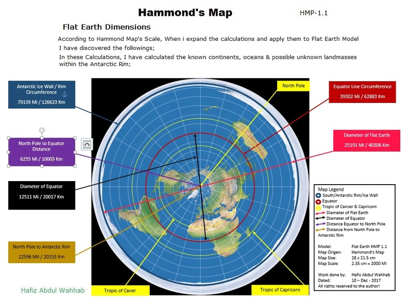
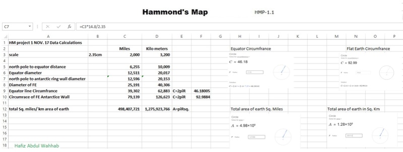
I were working on a project to calculate flat earth details according to hammond's map.
Project has been completed the details are as follows;


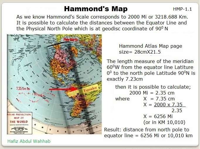
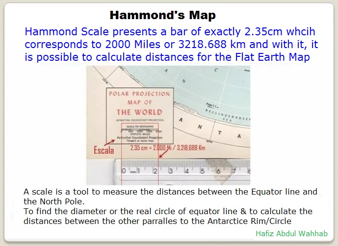
Project has been completed the details are as follows;


 Re: Flat Earth Maps
The beta version of hammond's map project is available. Final version will release soon.
Here's the link of Pdf file
https://drive.google.com/file/d/1KEJCJqQR26HVIGW9x0_rnXj1EoSWV20R/view?usp=drivesdk
Here's the link of Pdf file
https://drive.google.com/file/d/1KEJCJqQR26HVIGW9x0_rnXj1EoSWV20R/view?usp=drivesdk
Page 6 of 9 •  1, 2, 3, 4, 5, 6, 7, 8, 9
 Similar topics
» Flat Earth Audiobooks and PDFs
» Operation: Spread Flat Earth Truth
» Experiments We All Can Do
» The Earth Plane (Flat Earth Children's Book)
» Flat Earth FAQ
» Operation: Spread Flat Earth Truth
» Experiments We All Can Do
» The Earth Plane (Flat Earth Children's Book)
» Flat Earth FAQ
IFERS - Exposing the 'Global' Conspiracy From Atlantis to Zion :: Reference Materials, eBooks, Articles, Videos, Maps
Page 6 of 9
Permissions in this forum:
You cannot reply to topics in this forum