
Flat Earth Maps
IFERS - Exposing the 'Global' Conspiracy From Atlantis to Zion :: Reference Materials, eBooks, Articles, Videos, Maps
Page 4 of 9 •  1, 2, 3, 4, 5, 6, 7, 8, 9
 ![]()
Re: Flat Earth Maps
![]() by TravelinHero Sat Jan 16, 2016 11:17 pm
by TravelinHero Sat Jan 16, 2016 11:17 pm
TravelinHero- Posts : 1
Points : 3117
Reputation : 1
Join date : 2016-01-16
Re: Flat Earth Maps
![]() by Thinkforyourself Sun Jan 17, 2016 3:34 am
by Thinkforyourself Sun Jan 17, 2016 3:34 am
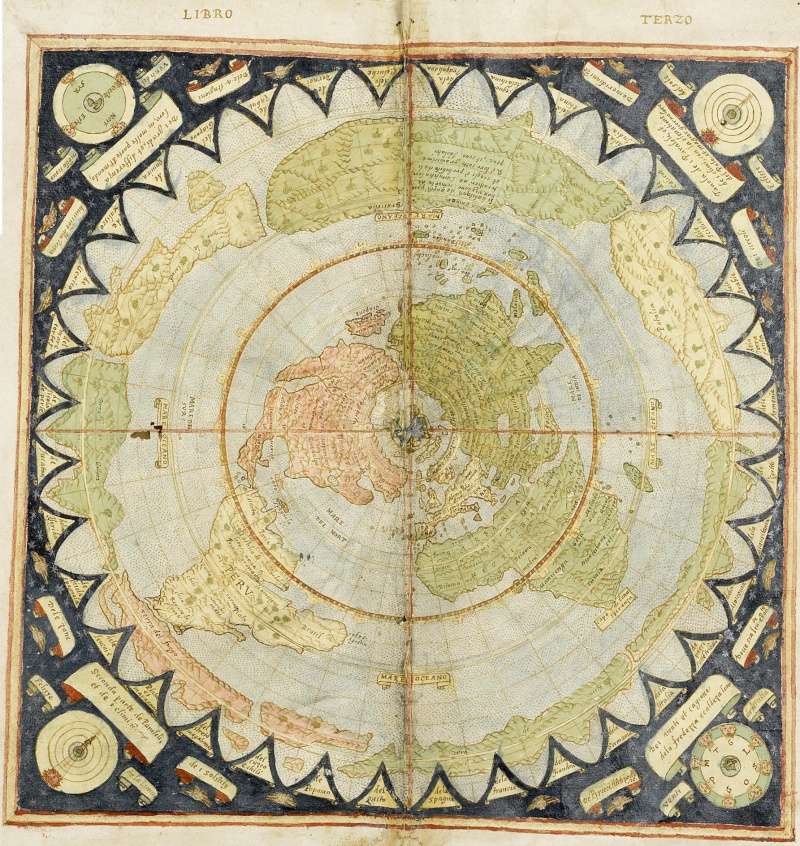
Yes, we have seen it. In fact, it has already been posted in this thread.TravelinHero wrote:Not so much a flat map, but have you seen the map of Piri Reis? Supposedly a map drawn in 1513 showing "accurately" Antarctica with no ice? very interesting.
It is extremely interesting, because it helps to confirm that the NWO hide parts of the planet from us, like they do at the 'North' pole, where they hide the 4 rivers, Mount Meru, and the mild climate, for various reasons. Mercator's maps of that area show that it is not all ice; in fact it is a landmass and many islands, and not all of it is frozen, as was confirmed by many explorer's in the 18th, 19th and early 20th centuries.
_________________
All about Shillaphobia
Shun the non-believers!
'Flat Earth Diva'
Supposed 'temper temper beanpole', 'snidy weasel' and 'clueless, cloying, sychophant.'
Apparently 'dangerous person'
Thinkforyourself- Admin
- Posts : 2048
Points : 8224
Reputation : 2862
Join date : 2015-12-30
Age : 35
Location : United Kingdom

lizardking- Posts : 1673
Points : 7480
Reputation : 2604
Join date : 2015-12-30
Age : 30
Location : United Kingdom
Re: Flat Earth Maps
![]() by Shad01 Mon Jan 18, 2016 10:41 am
by Shad01 Mon Jan 18, 2016 10:41 am
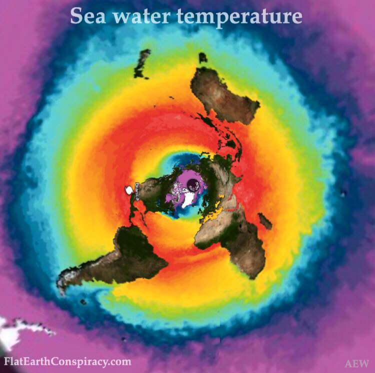
NASA image
Shad01- Posts : 3
Points : 3129
Reputation : 6
Join date : 2016-01-13
World Digital Library - Maps
![]() by vortexpuppy Sun Jan 31, 2016 5:29 pm
by vortexpuppy Sun Jan 31, 2016 5:29 pm
Not sure if it has been mentioned before.
It contains interesting titles of old books in many different languages and a decent search feature.
World Maps
https://www.wdl.org/en/search/?q=world+maps&qla=en
1. Mappamundi
https://www.wdl.org/en/item/6763
Little is known about the 15th-century Venetian geographer and cosmographer Giovanni Leardo, beyond the fact that three of his world maps have survived from late-medieval times, signed by their creator. This is the oldest world map held in the library of the American Geographical Society, and it is considered the finest example of a medieval mappamundi in the Western hemisphere.
2. Map of the whole world
https://www.wdl.org/en/item/11851
The first world map published in Japan appeared in 1645. Shown here is a popular version of that first map, published in 1671. It is divided into two parts: the right side contains an oblong egg-shaped world map with the east at the top, while the left side depicts people from 40 countries in national costume. The latter are arrayed in five rows of eight, depicting people both of existing countries, such as Portugal and the Netherlands, and imaginary countries, such as “Dwarf Country” and “Giant Country.”
3. Manusyaloka, Map of the Human World
https://www.wdl.org/en/item/3191
Jainism has its own version of geography and cosmology, in which the universe is divided into three kingdoms: the upper is the realm of the heavens and the celestials; the middle is the domain of humans, animals, and plants; and the lower, which belongs to the damned and the disorderly.
4. General Atlas of All the Islands in the World (700 pages)
https://www.wdl.org/en/item/10090
5. A Modern and Complete Map of the World by the Royal Mathematician Oronce Fine of the Dauphiné
https://www.wdl.org/en/item/4072
6. Cosmographical Map or Universal Description of the World with the Actual Path of the Winds
https://www.wdl.org/en/item/575
and many more .....
Other searches also lead to interesting titles ....
1. A New, Authentic, and Complete Collection of Voyages Round the World
https://www.wdl.org/en/item/2674
This compilation of British navigators' accounts of their voyages around the world covers the famous voyages of Sir Francis Drake and Captain James Cook, as well as expeditions by George Anson, John Byron, Samuel Wallis and Philip Carteret, and Constantine Phipps (Lord Mulgrave).
2. The World Encompassed by Sir Francis Drake
https://www.wdl.org/en/item/624
2. Voyage Around the World by the King's Frigate La Boudeuse and the Ship L'Etoile in 1766, 1767, 1768, and 1769
https://www.wdl.org/en/item/2673
Or in the Astronomy & allied sciences topic
https://www.wdl.org/en/topic/52/
are titles and descriptions such as:
1. The Book of the Delight of the Eye Regarding the Movement of the Two Luminaries
https://www.wdl.org/en/item/4295/
The second part of the introduction begins at folio 4 verso and is devoted to astronomical problems, in particular the movements of the sun and the moon in the sky.
2. The Light of the stars
https://www.wdl.org/en/item/4300/
While creating a model that was mathematically consistent with the Ptolemaic one, Ibn al-Shāṭir was able to formulate a planetary theory of circular uniform motion, in compliance with Aristotelian ideas on matter.
3. The Light of the Eyes and the Enlightened Landscape of Vision
https://www.wdl.org/en/item/2852/#institution=national-library-and-archives-egypt
This work is a noteworthy treatise on optics that covers such basic topics as direct vision, reflection and refraction, and the length of shadows. It discusses convex and concave mirrors and the physiology of vision, and has a section on optical illusions. It is a cogent work on geometrical optics
4. The Travelers Guide on Drawing the Circle of Projection
https://www.wdl.org/en/item/2853/#institution=national-library-and-archives-egypt
This is a work on timekeeping and the determination of the direction of prayer (qibla), particularly intended for people who travel. The author, Abu al-‛Abbās Shihāb al-Dīn Ahmad b. Zayn al-Dīn Rajab b. Tubayghā al-Atābakī, known as al-Majdī or Ibn al-Majdī (1366-1447 [767-850 A.H.]), was descended from a powerful family with ties to Mamlūk rulers and was a renowned and prominent mathematician, geometrician, and astronomer.
5. The Book of Instruction on Deviant Planes and Simple Planes
https://www.wdl.org/en/item/2856/#institution=national-library-and-archives-egypt
This manuscript is a work on practical astronomy and the drawing of the circle of projection and related concepts from spherical trigonometry. It is rich with geometric diagrams, tables of empirical observations, and computations based upon these observations. An interesting feature of the manuscript is the appearance on the margins of the cover, and on several pages in the manuscript, of edifying verses, proverbs, and witty remarks. One reads, for example, “It is strange to find in the world a jaundiced physician, a dim-eyed ophthalmologist, and a blind astronomer.” Most of the remarks applaud the virtues of silence. The manuscript is dated 1153 A.H. (1740).
I don't do many of the languages on offer, so not sure of the overall value to our research.
vortexpuppy- Posts : 167
Points : 3602
Reputation : 296
Join date : 2015-12-30
Re: Flat Earth Maps
![]() by FlatEartherInNH Wed Feb 03, 2016 2:47 pm
by FlatEartherInNH Wed Feb 03, 2016 2:47 pm
From what I read on the site where I found this, this was found in the Library of Congress.
I'll see if I can find that website again.....
Here's the front:

And here's the back:

FlatEartherInNH- Posts : 5
Points : 3133
Reputation : 12
Join date : 2016-01-15
Location : New Hampshire Longitude 70° 56' 53" W
Re: Flat Earth Maps
![]() by FlatEartherInNH Thu Feb 04, 2016 10:29 pm
by FlatEartherInNH Thu Feb 04, 2016 10:29 pm

I ran across some interesting info about this map today, haven't seen it posted elsewhere.
This map was US Patented back on May 23, 1893
Here's the link to the Google article about it: http://www.google.ca/patents/US497917
ALSO, here's a link to another Google article.
This is about the US Patent for a "Universal Planisphere Complete Guidance and Computer System" from January 7, 1975.
No wires, no batteries, no circuits whatsoever.
Looks a LOT like an astrolabe on steroids.
http://www.google.ca/patents/US3858334
What was even more interesting is that the Planisphere Patent uses the Gleason Map Patent as one if its Cited References.
Here is where I found all this: https://www.youtube.com/watch?v=-2YjLdgiok4
Vid is by Flat Water. Worth taking a look IMHO.
FlatEartherInNH- Posts : 5
Points : 3133
Reputation : 12
Join date : 2016-01-15
Location : New Hampshire Longitude 70° 56' 53" W
Re: Flat Earth Maps
![]() by susie Tue Mar 15, 2016 9:16 pm
by susie Tue Mar 15, 2016 9:16 pm
Good information concerning maps with reference to a flat earth north pole projection map.

susie- Posts : 851
Points : 4483
Reputation : 477
Join date : 2015-12-30
Age : 64
Location : NOLA -

Re: Flat Earth Maps
![]() by Themis Tue Mar 22, 2016 1:48 pm
by Themis Tue Mar 22, 2016 1:48 pm
From The White House yt channel:
Situation Room office in 1962

01:25

Themis- Posts : 48
Points : 3337
Reputation : 216
Join date : 2016-02-27
Re: Flat Earth Maps
![]() by Schpankme Sat Mar 26, 2016 6:07 pm
by Schpankme Sat Mar 26, 2016 6:07 pm
Litteämaa\" (Flat Earth) wrote:
This was interesting what rob skiba made
youtube.com/embed/pCWz5na8d1k
An angle was used to draw all the longitudinal lines, these reference marks fan out to the edge of the map, they are not to used for scaling objects or distance.
What we have here, is Rob Skiba selling Fake Globe Flights in the southern regions.

Schpankme- Posts : 1202
Points : 5961
Reputation : 1606
Join date : 2015-12-30
Re: Flat Earth Maps
![]() by susie Mon Apr 04, 2016 7:17 pm
by susie Mon Apr 04, 2016 7:17 pm
FlatEartherInNH wrote:Ran across this one, didn't see it in the threads.
From what I read on the site where I found this, this was found in the Library of Congress.
I'll see if I can find that website again.....
Here's the front:
And here's the back:
Pt 1
https://youtu.be/EvXEbh1hfzc
Pt 2
https://youtu.be/5O6HHd2XxyI
Pt 3 https://youtu.be/G04XR3YS3ow
Pt 4
https://youtu.be/0otEelweHbI
Hearst island
https://youtu.be/7Or_Dd0g75c
Occult symbolis
https://youtu.be/BfiCo0LVFuc
The Enlightenment of the World
https://youtu.be/e9lm05Ey72E
Brian Clark, Referencing the map on video.
susie- Posts : 851
Points : 4483
Reputation : 477
Join date : 2015-12-30
Age : 64
Location : NOLA -
Re: Flat Earth Maps
![]() by susie Thu Apr 07, 2016 8:53 pm
by susie Thu Apr 07, 2016 8:53 pm
susie wrote:FlatEartherInNH wrote:Ran across this one, didn't see it in the threads.
From what I read on the site where I found this, this was found in the Library of Congress.
I'll see if I can find that website again.....
Here's the front:
And here's the back:
Pt 1
https://youtu.be/EvXEbh1hfzc
Pt 2
https://youtu.be/5O6HHd2XxyI
Pt 3 https://youtu.be/G04XR3YS3ow
Pt 4
https://youtu.be/0otEelweHbI
Hearst island
https://youtu.be/7Or_Dd0g75c
Occult symbolis
https://youtu.be/BfiCo0LVFuc
The Enlightenment of the World
https://youtu.be/e9lm05Ey72E
Brian Clark, Referencing the map on video.
Antarctica Solved?
This guy has morphed his voice to a chipmunk and when he curses the dirty bastards club it is hilarious!
Last edited by susie on Fri Apr 08, 2016 9:28 pm; edited 1 time in total
susie- Posts : 851
Points : 4483
Reputation : 477
Join date : 2015-12-30
Age : 64
Location : NOLA -
Re: Flat Earth Maps
![]() by Themis Thu Apr 07, 2016 10:00 pm
by Themis Thu Apr 07, 2016 10:00 pm

Last edited by Themis on Sat May 14, 2016 11:26 pm; edited 2 times in total
Themis- Posts : 48
Points : 3337
Reputation : 216
Join date : 2016-02-27
Re: Flat Earth Maps
![]() by csp Fri Apr 08, 2016 4:06 am
by csp Fri Apr 08, 2016 4:06 am
susie wrote:Antarctica Solved?
Hm, overlaying a portion of the "globe" over the Abizaid map is a pretty pointless task in my opinion, as we know most modern projections distort the sizes, and thus relative positions of continents.
Seeing as Antarctica is completely controlled, and not open for exploration, I would too speculate that the place where organised "flights" and "cruises" visit is actually a land mass close to the "southern circle" as mentioned in the video.
Unfortunately I don't see this "solving" anything per se, just raising more questions.

csp- Posts : 424
Points : 4607
Reputation : 1054
Join date : 2016-01-04
Location : Australia
Re: Flat Earth Maps
![]() by csp Fri Apr 08, 2016 7:48 am
by csp Fri Apr 08, 2016 7:48 am
csp- Posts : 424
Points : 4607
Reputation : 1054
Join date : 2016-01-04
Location : Australia
Re: Flat Earth Maps
![]() by Themis Mon Apr 11, 2016 2:02 am
by Themis Mon Apr 11, 2016 2:02 am

Last edited by Themis on Sat May 14, 2016 11:25 pm; edited 1 time in total
Themis- Posts : 48
Points : 3337
Reputation : 216
Join date : 2016-02-27
Re: Flat Earth Maps
![]() by anko Tue Apr 19, 2016 2:05 am
by anko Tue Apr 19, 2016 2:05 am

Sceenshot taken from this YouTube-video at [1:00:50]:
https://www.youtube.com/watch?v=qfyeVdZ7zcw
This map is on a wall at a marine station in Germany.
Love and Peace.
anko- Posts : 3
Points : 3069
Reputation : 10
Join date : 2016-03-19
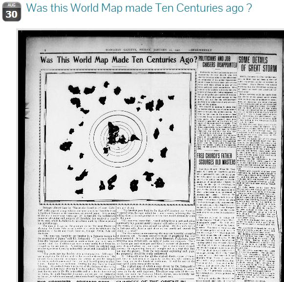
Flat Earth map in the Hawaiin Gazette in 1907
![]() by riggie11 Sun Jun 19, 2016 1:33 pm
by riggie11 Sun Jun 19, 2016 1:33 pm
http://chroniclingamerica.loc.gov/lccn/sn83025121/1907-01-11/ed-1/seq-2/
riggie11- Posts : 1
Points : 3118
Reputation : 2
Join date : 2016-01-16
Re: Flat Earth Maps
![]() by Thinkforyourself Mon Aug 01, 2016 6:31 pm
by Thinkforyourself Mon Aug 01, 2016 6:31 pm
riggie11 wrote:I found this map from within an article in the Hawaiin Gazette in 1907. Really interesting...
http://chroniclingamerica.loc.gov/lccn/sn83025121/1907-01-11/ed-1/seq-2/
Very interesting. Thanks for posting.
_________________
All about Shillaphobia
Shun the non-believers!
'Flat Earth Diva'
Supposed 'temper temper beanpole', 'snidy weasel' and 'clueless, cloying, sychophant.'
Apparently 'dangerous person'
Thinkforyourself- Admin
- Posts : 2048
Points : 8224
Reputation : 2862
Join date : 2015-12-30
Age : 35
Location : United Kingdom
csp- Posts : 424
Points : 4607
Reputation : 1054
Join date : 2016-01-04
Location : Australia
Re: Flat Earth Maps
![]() by mitch Thu Sep 01, 2016 4:49 pm
by mitch Thu Sep 01, 2016 4:49 pm
The Hawaiian gazette., January 11, 1907
You can zoom in on webpage
mitch- Posts : 130
Points : 3533
Reputation : 279
Join date : 2016-01-08
Location : Northumbria
Re: Flat Earth Maps
![]() by _Madison Sat Nov 12, 2016 5:32 pm
by _Madison Sat Nov 12, 2016 5:32 pm
I also believe the above "1000 year old" map to be disinformation. Notice it's 33 extra continents.
@zero_curvature
_Madison- Posts : 1
Points : 2816
Reputation : 1
Join date : 2016-11-12
Re: Flat Earth Maps
![]() by ABalancedKarma Fri Nov 18, 2016 9:21 pm
by ABalancedKarma Fri Nov 18, 2016 9:21 pm

ABalancedKarma- Posts : 36
Points : 2895
Reputation : 52
Join date : 2016-11-17
Dr Zack needs help to create accurate flat earth map
![]() by VeroSercanto Mon Nov 21, 2016 11:08 pm
by VeroSercanto Mon Nov 21, 2016 11:08 pm
See this guy's video on his project here:
Thanks
VeroSercanto- Posts : 1
Points : 2806
Reputation : 0
Join date : 2016-11-21
Re: Flat Earth Maps
![]() by ebcih Thu Nov 24, 2016 4:11 am
by ebcih Thu Nov 24, 2016 4:11 am
_Madison wrote:I believe you've been looking for this.
I also believe the above "1000 year old" map to be disinformation. Notice it's 33 extra continents.
@zero_curvature
This map looks really interesting. Any info where it's from?
ebcih- Posts : 1
Points : 2805
Reputation : 0
Join date : 2016-11-22
Age : 35
Location : Finland
Page 4 of 9 • 1, 2, 3, 4, 5, 6, 7, 8, 9 ![]()
» Operation: Spread Flat Earth Truth
» The Earth Plane (Flat Earth Children's Book)
» Experiments We All Can Do
» The Flat Moon Over the Flat Earth
IFERS - Exposing the 'Global' Conspiracy From Atlantis to Zion :: Reference Materials, eBooks, Articles, Videos, Maps
|
|
|