Flight Routes, Shipping Routes, Under Sea Cables
+29
dee_elle_iii
Shane_St_Pierre
FE_AirlinePilot
Reecus
Truthmania
daride
Freepressfreepeople
Gemini
Shmack_1
unexplainedelefants
Ant
markwilson
Wertikal
Real World
observer
Just Vital
InnerCynic
Admin
Realearth
blackchoy
Bobby Peru
FL@T-E@RTH
inerratic
Beashambassador
csp
feblogger
californian
lizardking
Schpankme
33 posters
IFERS - Exposing the 'Global' Conspiracy From Atlantis to Zion :: The International Flat Earth Research Society
Page 1 of 5
Page 1 of 5 • 1, 2, 3, 4, 5 
 Flight Routes, Shipping Routes, Under Sea Cables
Post by Admin on Mar 1, 2015
If the Earth were a sphere, airplane pilots would have to constantly correct their altitudes downwards so as to not fly straight off into “outer space!” If the Earth were truly a sphere 25,000 miles circumference curveting 8 inches per mile squared, a pilot wishing to simply maintain their altitude at a typical cruising speed of 500 mph, would have to constantly dip their nose downwards and descend 2,777 feet (over half a mile) every minute! Otherwise, without compensation, in one hour’s time the pilot would find themselves 166,666 feet (31.5 miles) higher than expected!
A plane flying at a typical 35,000 feet wishing to maintain that altitude at the upper-rim of the so-called “Troposphere” in one hour would find themselves over 200,000 feet high into the “Mesosphere” with a steadily raising trajectory the longer they go. I have talked to several pilots, and no such compensation for the Earth’s supposed curvature is ever made. When pilots set an altitude, their artificial horizon gauge remains level and so does their course; nothing like the necessary 2,777 foot per minute declination is ever taken into consideration.
~ Eric Dubay
The Earth is Not Moving!
The heliocentric theory, literally “flying” in the face of direct observation, experimental evidence and common sense, maintains that the ball-Earth is spinning around its axis at 1,000 miles per hour; revolving around the Sun at 67,000 miles per hour; while the entire solar system rotates around the Milky Way galaxy at 500,000 miles per hour; and the Milky Way speeds through the expanding Universe at over 670,000,000 miles per hour; yet no one in history has ever felt a thing!
We can feel the slightest breeze on a summer’s day, but never one iota of air displacement from these incredible speeds! Heliocentrists claim with a straight face that their ball-Earth spins at a constant velocity dragging the atmosphere in such a manner as to perfectly cancel all centrifugal, gravitational, and inertial forces so we do not feel the tiniest bit of motion, perturbation, wind or air resistance! Such back-peddling, damage-control reverse-engineered explanations certainly stretch the limits of credibility and the imagination, leaving much to be desired by discerning minds.
If the Earth and atmosphere are constantly revolving Eastwards at 1,000 mph, how is it that clouds, wind, and weather patterns casually and unpredictably go every which way, often travelling in opposing directions simultaneously?
Why can we feel the slightest Westward breeze but not the Earth’s incredible supposed 1,000 mph Eastward spin!? And how is it that the magic velcro of gravity is strong enough to drag miles of Earth’s atmosphere along, but weak enough to allow little bugs, birds, clouds and planes to travel freely unabated in any direction?
http://www.atlanteanconspiracy.com/2014/11/the-flat-earth-conspiracy.html

Schpankme- Posts : 1202
Points : 6080
Reputation : 1606
Join date : 2015-12-30
 Re: Flight Routes, Shipping Routes, Under Sea Cables
Post by Admin on Mar 23, 2015
Judging from flight times/distances it seems to be around 7000 miles from the Southern tip of South America to the Southern tip of Australia/NZ. From there it is hundreds of miles further in both directions to the Antarctic ice, but then how much farther Southwards the ice extends is unknown to the public, so ascertaining the exact diameter is impossible at the moment.
Judging from flight times/distances it seems to be around 7000 miles from the Southern tip of South America to the Southern tip of Australia/NZ. From there it is hundreds of miles further in both directions to the Antarctic ice, but then how much farther Southwards the ice extends is unknown to the public, so ascertaining the exact diameter is impossible at the moment.

Schpankme- Posts : 1202
Points : 6080
Reputation : 1606
Join date : 2015-12-30
 Re: Flight Routes, Shipping Routes, Under Sea Cables
Post by Admin on Mar 23, 2015
When light of any kind shines through a dense medium it appears larger, or rather gives a greater glare, at a given distance than when it is seen through a lighter medium. This is more remarkable when the medium holds aqueous particles or vapor in solution, as in a damp or foggy atmosphere. You can see this by standing within a few yards of a street lamp, and noticing the size of the light; on going away to many times the distance, the light upon the atmosphere will appear considerably larger. This phenomenon may be noticed, to a greater or less degree, at all times; but when the air is moist and vapory it is more intense. It is evident that at sunrise, and at sunset, the sun's light must shine through a greater length of atmospheric air than at mid-day; besides which, the air near the earth is both more dense, and holds more watery particles in solution, than the higher strata through which the sun shines at noonday; and hence the light must be dilated or magnified, as well as modified in color.
When light of any kind shines through a dense medium it appears larger, or rather gives a greater glare, at a given distance than when it is seen through a lighter medium. This is more remarkable when the medium holds aqueous particles or vapor in solution, as in a damp or foggy atmosphere. You can see this by standing within a few yards of a street lamp, and noticing the size of the light; on going away to many times the distance, the light upon the atmosphere will appear considerably larger. This phenomenon may be noticed, to a greater or less degree, at all times; but when the air is moist and vapory it is more intense. It is evident that at sunrise, and at sunset, the sun's light must shine through a greater length of atmospheric air than at mid-day; besides which, the air near the earth is both more dense, and holds more watery particles in solution, than the higher strata through which the sun shines at noonday; and hence the light must be dilated or magnified, as well as modified in color.

Schpankme- Posts : 1202
Points : 6080
Reputation : 1606
Join date : 2015-12-30
 Re: Flight Routes, Shipping Routes, Under Sea Cables
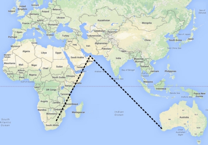
Check out the flight: Perth > Dubai > Johannesburg
Melbourne to Cape of Good Hope is 7140 nautical miles.
Melbourne to Liverpool is 14,688 nautical miles.
Cape of Good Hope to Liverpool is 7548 nautical miles.
Cape of Good Hope to Sydney is 8452 nautical miles or
Melbourne to Cape of Good Hope is 7140 nautical miles.
Melbourne to Liverpool is 14,688 nautical miles.
Cape of Good Hope to Liverpool is 7548 nautical miles.
Cape of Good Hope to Sydney is 8452 nautical miles or
Last edited by Schpankme on Sat Apr 22, 2017 4:39 pm; edited 1 time in total

Schpankme- Posts : 1202
Points : 6080
Reputation : 1606
Join date : 2015-12-30
 Re: Flight Routes, Shipping Routes, Under Sea Cables
I went to check the flight routes on planefinder.com to see if this is actually happening. I noticed only one plane attempting to fly across the Ocean on the southern hemisphere. It was a flight from Santiago Chile to Doha Qatar. After few minutes the plane vanished from the map. Also I was able to predict other routes by looking on the flat map alone. It's one thing to speculate but seeing this stuff actually works is quite another.
Last edited by Schpankme on Sat Aug 17, 2019 2:42 am; edited 1 time in total

Schpankme- Posts : 1202
Points : 6080
Reputation : 1606
Join date : 2015-12-30
 Re: Flight Routes, Shipping Routes, Under Sea Cables
Lets discuss the Flat Earth Map and Flights from South America to Australia. Many ignorant individuals and shills are claiming Flights from "Santiago Chile to Sydney Australia" won't work on the Flat Earth Map.
Here's why they're wrong:
From: Santiago,CL (SCL)
To: Sydney,AU (SYD)
Use "farecompare" to check Depart and Return dates, you will see that the first few Flights are bogus showing half the distance required; you will also NOTICE that QANTAS does not Service SCL, you must always change Planes in the United States.
Flight
LA 801 SCL to SYD 18:35 hours 1 stop AKL 7337 miles
UA 846 SCL to SYD 43:30 hpurs 2 stop IAH, SFO 13713 miles
See the first flight, LA 801, claims one stop in 7337 miles; this is a bogus flight, created using averaged Miles and Speed based on Google Maps, not an actual Flight.
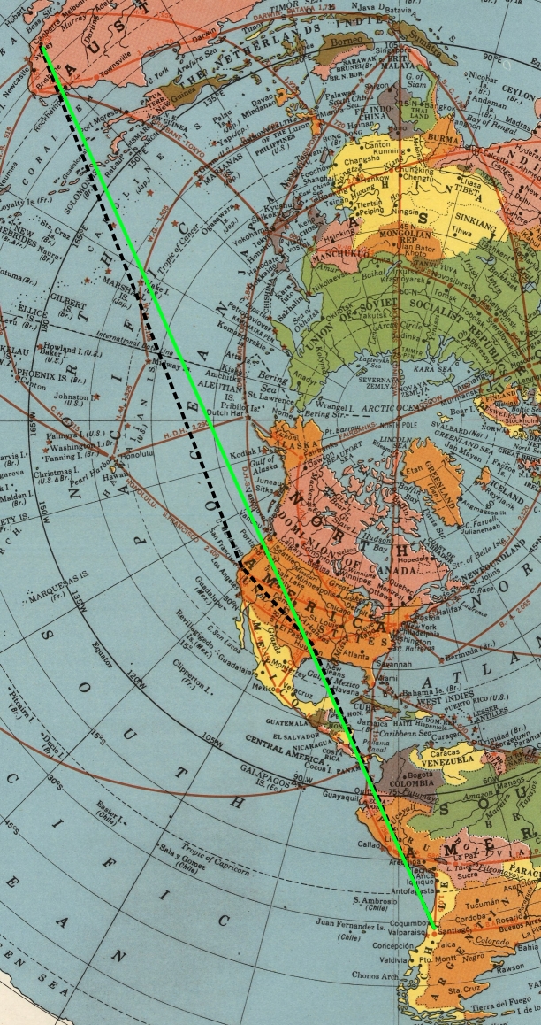
Flight UA 846
The Black-Line indicates the actual flight route with Stops; in "Huston, Texas" and "San Francisco, California".
The Green-Line shows what could be non-stop for something like the Military.
This mass of dis-info related to Flights originating out of South America has been a consolidated effort to discredit the Flat Earth you live on.
Ballers are going to bullshit, they already beLIEve about people living above and below them.
Here's why they're wrong:
From: Santiago,CL (SCL)
To: Sydney,AU (SYD)
Use "farecompare" to check Depart and Return dates, you will see that the first few Flights are bogus showing half the distance required; you will also NOTICE that QANTAS does not Service SCL, you must always change Planes in the United States.
Flight
LA 801 SCL to SYD 18:35 hours 1 stop AKL 7337 miles
UA 846 SCL to SYD 43:30 hpurs 2 stop IAH, SFO 13713 miles
See the first flight, LA 801, claims one stop in 7337 miles; this is a bogus flight, created using averaged Miles and Speed based on Google Maps, not an actual Flight.
Flight UA 846
The Black-Line indicates the actual flight route with Stops; in "Huston, Texas" and "San Francisco, California".
The Green-Line shows what could be non-stop for something like the Military.

This mass of dis-info related to Flights originating out of South America has been a consolidated effort to discredit the Flat Earth you live on.
Ballers are going to bullshit, they already beLIEve about people living above and below them.
Last edited by Schpankme on Tue Jan 12, 2016 7:29 pm; edited 2 times in total

Schpankme- Posts : 1202
Points : 6080
Reputation : 1606
Join date : 2015-12-30
 Re: Flight Routes, Shipping Routes, Under Sea Cables
This Flight is Bogus, created using Google Maps Distance for and Average Aircraft Speed.
QF 64
JNB to SYD
06/04 06:10 PM - 06/05 02:00 PM 11:50
Non-Stop
6847 miles
...
This Flight is Real
EK 766
JNB to SYD
06/04 10:20 PM - 06/06 06:05 AM 23:45
1 Stop at DXB (Dubai)
11461 miles
...
21 Feb, 2014
Qantas abandons its alliance with South African Airways, which share flights between Australia and Johannesburg.
Qantas says it will will no longer offer bookings on 'South African Airways', flights from Perth to Johannesburg.
Instead, Qantas will offer flights via Dubai with its partner Emirates, which operates three daily services between
Perth and Dubai with onward connections to Johannesburg, Cape Town and Durban.
That means a long trek for the Flying Kangaroo's Perth passengers.
Flight from Johannesburg, ZA (JNB) to Perth, AU (PER), with Stop in Dubai:
Flight EK 766
JNB to PER
Stop 1 DXB (Dubai)
Miles 9597
Flat Earth map shows Flights in correct alignment, as would be expected.

Baller Earth map shows Flights going out of the way, this is absurd.
QF 64
JNB to SYD
06/04 06:10 PM - 06/05 02:00 PM 11:50
Non-Stop
6847 miles
...
This Flight is Real
EK 766
JNB to SYD
06/04 10:20 PM - 06/06 06:05 AM 23:45
1 Stop at DXB (Dubai)
11461 miles
...
21 Feb, 2014
Qantas abandons its alliance with South African Airways, which share flights between Australia and Johannesburg.
Qantas says it will will no longer offer bookings on 'South African Airways', flights from Perth to Johannesburg.
Instead, Qantas will offer flights via Dubai with its partner Emirates, which operates three daily services between
Perth and Dubai with onward connections to Johannesburg, Cape Town and Durban.
That means a long trek for the Flying Kangaroo's Perth passengers.
Flight from Johannesburg, ZA (JNB) to Perth, AU (PER), with Stop in Dubai:
Flight EK 766
JNB to PER
Stop 1 DXB (Dubai)
Miles 9597
Flat Earth map shows Flights in correct alignment, as would be expected.

Baller Earth map shows Flights going out of the way, this is absurd.

Last edited by Schpankme on Thu Jan 14, 2016 7:29 am; edited 1 time in total

Schpankme- Posts : 1202
Points : 6080
Reputation : 1606
Join date : 2015-12-30
 Re: Flight Routes, Shipping Routes, Under Sea Cables
Post by rollingthunder on May 5, 2015
I made a video on the southern hemisphere flights a few weeks ago using farecompare's flight search. Schpankme discovered that they had changed their website and also changed the way you could track flights. Here is a link I saved that still uses the old search format:
www.farecompare.com/products/schedules/index.html
You will get a totally different search format now if you go directly to farecompare. A few things have changed just in the last few weeks...one being that the non stop that was listed from SYD to SCL, flight 27 by Quantas, no longer exists on the old search format, but they have added another one stop through NZ, which I don't believe either flight exists, as they would be 6,000 mile flights in 11 hours 20 minutes. Just a coincidence on the timing of their website change, or did we find a weak spot? Here is the video I made if you would like to take a look
I was thinking that shipping routes would be a similar tell. Has anyone done research on shipping routes? I didn't see anything on youtube addressing them. Cheers

Schpankme- Posts : 1202
Points : 6080
Reputation : 1606
Join date : 2015-12-30
Truthmania and LevelEarth like this post
 Re: Flight Routes, Shipping Routes, Under Sea Cables
Turkish Airlines 10 (THY10)
Los Angeles Intl (KLAX) – to – Istanbul Ataturk Int’l (LTBA / IST)
Duration: 12 hours 1 minutes
Sunday, December 13, 2015
FlightAware – Live Flight Tracking
Distance Flown: 7,093 sm
Flight tracked on the Magical Ball Earth:
fly’s from LAX north through Canada, over Greenland, across Iceland, and Sweden, before arriving in Istanbul.
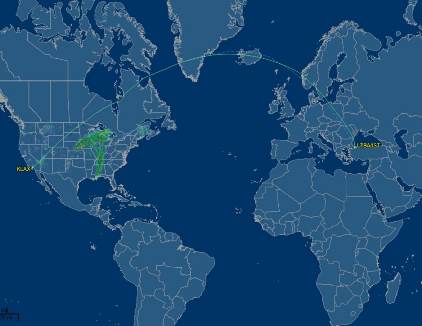
You would think on the Magical Ball Earth the shortest flight would be LAX – Newfoundland – Dublin – Istanbul ?

Here’s how the flight actually looks on the Flat Earth.
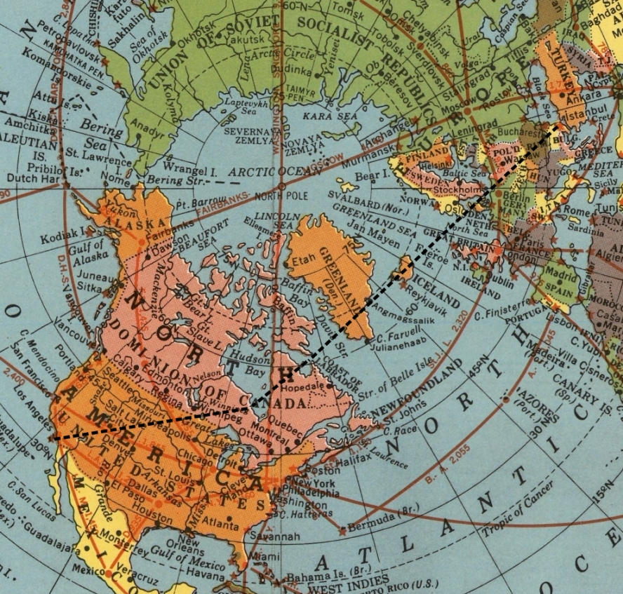
Los Angeles Intl (KLAX) – to – Istanbul Ataturk Int’l (LTBA / IST)
Duration: 12 hours 1 minutes
Sunday, December 13, 2015
FlightAware – Live Flight Tracking
Distance Flown: 7,093 sm
Flight tracked on the Magical Ball Earth:
fly’s from LAX north through Canada, over Greenland, across Iceland, and Sweden, before arriving in Istanbul.

You would think on the Magical Ball Earth the shortest flight would be LAX – Newfoundland – Dublin – Istanbul ?

Here’s how the flight actually looks on the Flat Earth.


Schpankme- Posts : 1202
Points : 6080
Reputation : 1606
Join date : 2015-12-30
 Re: Flight Routes, Shipping Routes, Under Sea Cables
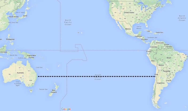
There are NO commercial "non-stop" Flights from South America to Australia/New Zealand
There are NO commercial Shipping routes from South America to Australia/New Zealand
There are NO commercial under-sea cables from South America to Australia/New Zealand
As can be seen, the Magical Ball Earth has it's limitations.
Compare with the Flat Earth - you will see that the Fiber Trunks run from North America to Australia; NOT from South America to Australia; exactly like Flight Routes.
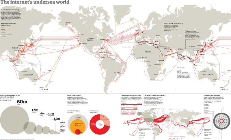
There are NO commercial Shipping routes from South America to Australia/New Zealand
There are NO commercial under-sea cables from South America to Australia/New Zealand
As can be seen, the Magical Ball Earth has it's limitations.

Compare with the Flat Earth - you will see that the Fiber Trunks run from North America to Australia; NOT from South America to Australia; exactly like Flight Routes.

Last edited by Schpankme on Thu Jan 14, 2016 7:42 am; edited 1 time in total

Schpankme- Posts : 1202
Points : 6080
Reputation : 1606
Join date : 2015-12-30
 Re: Flight Routes, Shipping Routes, Under Sea Cables
Posted by susie on 06/15/2015
Not "flight routes" but shipping routes. Wasnt sure about where to put this.
Ball Earth Skeptics-Flight Routes Exposed!
Not "flight routes" but shipping routes. Wasnt sure about where to put this.
Ball Earth Skeptics-Flight Routes Exposed!

Schpankme- Posts : 1202
Points : 6080
Reputation : 1606
Join date : 2015-12-30

Schpankme- Posts : 1202
Points : 6080
Reputation : 1606
Join date : 2015-12-30
 Re: Flight Routes, Shipping Routes, Under Sea Cables
PEARL HARBOR ATTACKED BY JAPAN?
The Japanese Navy departs their home waters of Tankan Bay (Hittokapu Bay) at 0900 hours, on 26 November 1941.
26 November 1941 - Japanese Fleet leaves Tankan Bay, Japan (Novem in Latin means 9, which is now the 11 month).
7 December 1941 - Pearl Harbor Attacked by Planes from Japanese Aircraft Carriers
----
11 days for the Japanese Fleet to reach Pearl Harbor
[19th Bombardment Group] were operating '12 Boeing B-17 Flying Fortresses' over Pearl Harbor during the attack.
353 Japanese fighters, bombers and torpedo planes attacked [11]
2403 Americans were killed [9]
29 aircraft destroyed [11]
65 servicemen killed or wounded [11]
9 December, 19th Bombardment Group fly reconnaissance missions in search of the Japanese fleet.
11 December, the U.S. declares War
9 = Fake News Event
11 = Physical Assets Involved
Japanese Military build reinforced bunkers and refueling stations in the Aleutian Islands.
In other words, on the Ball Earth the Japanese would need to steam North, North East from Japan to reach the Aleutian Islands; absolutely out of their way and of no strategic importance.
However, on the Flat Earth the Aleutian Islands are on the way to the Coast of North America. We are told that the Japaneses abandoned these Island fortification when the Weather and
Local natives became to extreme.
Baller Story Line
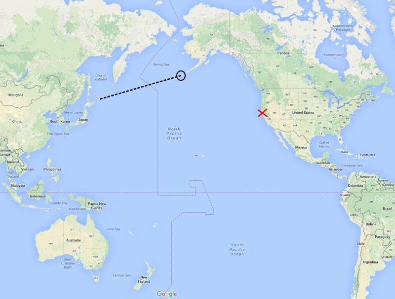
Flat Earth Reality
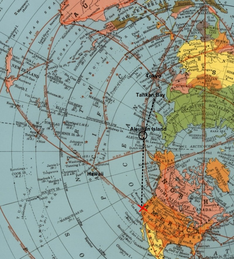
With the Japanese Depot in the Aleutian Islands they were able to wage war across the Pacific (Midway, Wake Island, Marshall Island, etc).
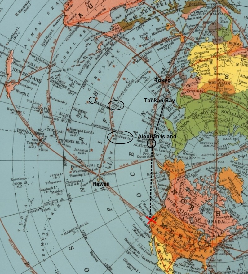
The Japanese Navy departs their home waters of Tankan Bay (Hittokapu Bay) at 0900 hours, on 26 November 1941.
26 November 1941 - Japanese Fleet leaves Tankan Bay, Japan (Novem in Latin means 9, which is now the 11 month).
7 December 1941 - Pearl Harbor Attacked by Planes from Japanese Aircraft Carriers
----
11 days for the Japanese Fleet to reach Pearl Harbor
[19th Bombardment Group] were operating '12 Boeing B-17 Flying Fortresses' over Pearl Harbor during the attack.
353 Japanese fighters, bombers and torpedo planes attacked [11]
2403 Americans were killed [9]
29 aircraft destroyed [11]
65 servicemen killed or wounded [11]
9 December, 19th Bombardment Group fly reconnaissance missions in search of the Japanese fleet.
11 December, the U.S. declares War
9 = Fake News Event
11 = Physical Assets Involved
Japanese Military build reinforced bunkers and refueling stations in the Aleutian Islands.
In other words, on the Ball Earth the Japanese would need to steam North, North East from Japan to reach the Aleutian Islands; absolutely out of their way and of no strategic importance.
However, on the Flat Earth the Aleutian Islands are on the way to the Coast of North America. We are told that the Japaneses abandoned these Island fortification when the Weather and
Local natives became to extreme.
Baller Story Line

Flat Earth Reality

With the Japanese Depot in the Aleutian Islands they were able to wage war across the Pacific (Midway, Wake Island, Marshall Island, etc).


Schpankme- Posts : 1202
Points : 6080
Reputation : 1606
Join date : 2015-12-30
 Re: Flight Routes, Shipping Routes, Under Sea Cables
Posted by micra on 06/03/2015
There has been some mention of plane tracking or lack of it.
Something that has come up is with reference to the disappearance of Malaysian flight MH370.
Lots of boo hoo about the inability to track flights so
here
www.popularmechanics.com/flight/a13340/mh370-missing-jets-tracking-technology-17521859/
explains why airliners don't have real time tracking.
Perhaps its because there are no satellites, and when the plane leaves the range of ground based tracking they are "lost".
The UN aviation body (whoever they are) are proposing a change
here:
www.voanews.com/content/reu-un-aviation-body-to-propose-15-minute-flight-tracking-standard/2588127.html
One interesting line from that report reads:
"Many airlines already track their planes using satellite systems. An ICAO working paper recently noted that the majority of long-haul aircraft already have systems on board that can transmit their position.
But it noted that the equipment is not always turned on and that in some locations, including along polar routes, there are gaps in satellite coverage".
What is interesting is that a task force set up by the International Air Transport Association, with the support of the International Civil Aviation Organization, proposed a new standard that, by December 2015, commercial aircraft must report their position every 15 minutes.
It will be interesting to see if this ever gets adopted.
Not that the general person would be party to such restricted information.
But it will be interesting to see if the proposal gets forgotten.
As a side note maybe MH370 was heading south in search of "the edge",
why else would the Australians be searching a thousand miles west of Perth.
here:
www.news.com.au/travel/travel-updates/mh370-missing-malaysia-airlines-plane-search-might-be-in-wrong-spot-investigators-say/story-fnizu68q-1227084277721
I'm new to ifers and I hope I haven't duplicated previous comments/posts.
Best Wishes all.
Peace and Love

lizardking- Posts : 1673
Points : 7599
Reputation : 2604
Join date : 2015-12-30
Age : 31
Location : United Kingdom
 Re: Flight Routes, Shipping Routes, Under Sea Cables
Posted by lizardking on 05/12/2015
How can a theory be interesting if you just dismiss it out of hand? And how the hell do you figure that Flat Earth doesn't doesn't work "within our current understanding of sensory perception"? NASA has worked actively to blind everyone to their sensory perception in order to convince anyone of this utter guff. When you go outside, you cannot be certain that you are on top of a BALL, spinning around, rotating in our Solar system, whizzing through Space at 60k miles per hour.
You cannot disprove what Schpankme said.
ifers.boards.net/post/5884/thread
Keep believing in unsupported, fantastical pseudo-science, literally poached from a nerd's dreams about Star Trek.
May 11, 2015 21:20:51 GMT realz said:
'shill', really? You think the global puppet masters are paying me? No. Flat earth theory is interesting and a great example of how we need to question everything we're told but the earth is not flat, or at least not flat within our current understanding of physics and sensory perception. You can book these flights and get on these planes! People only tend to book via Dubai if they are getting cheaper tickets.
How can a theory be interesting if you just dismiss it out of hand? And how the hell do you figure that Flat Earth doesn't doesn't work "within our current understanding of sensory perception"? NASA has worked actively to blind everyone to their sensory perception in order to convince anyone of this utter guff. When you go outside, you cannot be certain that you are on top of a BALL, spinning around, rotating in our Solar system, whizzing through Space at 60k miles per hour.
You cannot disprove what Schpankme said.
ifers.boards.net/post/5884/thread
Keep believing in unsupported, fantastical pseudo-science, literally poached from a nerd's dreams about Star Trek.

lizardking- Posts : 1673
Points : 7599
Reputation : 2604
Join date : 2015-12-30
Age : 31
Location : United Kingdom
 Re: Flight Routes, Shipping Routes, Under Sea Cables
Posted by thinkforyourself on 07/02/2015
Thanks for this very interesting find. I fully agree with you; it is because they don't have satellites and because they won't allow genuine commercial flights over the Antarctic.
Jun 2, 2015 16:07:26 GMT micra said:
There has been some mention of plane tracking or lack of it.
Something that has come up is with reference to the disappearance of Malaysian flight MH370.
Thanks for this very interesting find. I fully agree with you; it is because they don't have satellites and because they won't allow genuine commercial flights over the Antarctic.

lizardking- Posts : 1673
Points : 7599
Reputation : 2604
Join date : 2015-12-30
Age : 31
Location : United Kingdom
 Re: Flight Routes, Shipping Routes, Under Sea Cables
Posted by culzean on 07/10/2015
Hi Guys,
This is the map for the 'Round the Globe' Volvo Ocean Race. I have a cousin who competed in the 2011/12 edition.

Initially, when looking into the flat earth, I found it hard to reconcile my own cousin's claim of 'global circumnavigation'. However, look at this above route map, and take particular note of the wide curve out into the Southern/Indian Ocean on the route from Cape Town to Abu Dhabi. I used to wonder why this was done, when there's absolutely no reason to take such a wide-berth around Madagascar... Interestingly, the map above lists the distance for the Alicante to Cape Town leg as '6125nm', but The Official Report lists the sailed distance - in practice - as '8500nm'. Meaning the boats sailed a lot further than the route suggested they would.
I was hoping someone could reconcile the distances, particularly the leg from Auckland to Itajai. It's listed as being '6776nm', in the pre-race image shown above. However, the post-race data shows that it was '7200nm'. I have not seen a flat earth map that suggests it's possible to cover only 7,200nm in sailing from Auckland to Brazil? When it is 8500nm from Spain to South Africa?
Thanks, enjoy reading all your posts.
Hi Guys,
This is the map for the 'Round the Globe' Volvo Ocean Race. I have a cousin who competed in the 2011/12 edition.

Initially, when looking into the flat earth, I found it hard to reconcile my own cousin's claim of 'global circumnavigation'. However, look at this above route map, and take particular note of the wide curve out into the Southern/Indian Ocean on the route from Cape Town to Abu Dhabi. I used to wonder why this was done, when there's absolutely no reason to take such a wide-berth around Madagascar... Interestingly, the map above lists the distance for the Alicante to Cape Town leg as '6125nm', but The Official Report lists the sailed distance - in practice - as '8500nm'. Meaning the boats sailed a lot further than the route suggested they would.
I was hoping someone could reconcile the distances, particularly the leg from Auckland to Itajai. It's listed as being '6776nm', in the pre-race image shown above. However, the post-race data shows that it was '7200nm'. I have not seen a flat earth map that suggests it's possible to cover only 7,200nm in sailing from Auckland to Brazil? When it is 8500nm from Spain to South Africa?
Thanks, enjoy reading all your posts.

lizardking- Posts : 1673
Points : 7599
Reputation : 2604
Join date : 2015-12-30
Age : 31
Location : United Kingdom
 Re: Flight Routes, Shipping Routes, Under Sea Cables
Posted by csp on 07/10/2015
Hi culzean,
Great find, great first post - welcome
Hi culzean,
Great find, great first post - welcome

lizardking- Posts : 1673
Points : 7599
Reputation : 2604
Join date : 2015-12-30
Age : 31
Location : United Kingdom
 Re: Flight Routes, Shipping Routes, Under Sea Cables
Posted by jimmytamp on 07/12/2015
I looked up at Qantas' website to book the SYD-SCL flight and found this:
"QF27 on Sundays is subject to government and regulatory approval"
As far as I know, this statement is only given by the Airline for the future/proposed flight but not for a flight which has already exist.

Jul 12, 2015 6:08:13 GMT csp said:
vamsi108,
11,645 km
Distance from Hong Kong to Los Angeles, CA
Flights take ~13-14 hours non-stop according to flight booking services
11,340 km
Distance from Sydney NSW to Santiago
Flights take ~16-17 hours non-stop according to flight booking services
However I personally don't believe the flights from Sydney to Santiago go direct. Either way, there is a large discrepancy in time.
I looked up at Qantas' website to book the SYD-SCL flight and found this:
"QF27 on Sundays is subject to government and regulatory approval"
As far as I know, this statement is only given by the Airline for the future/proposed flight but not for a flight which has already exist.


lizardking- Posts : 1673
Points : 7599
Reputation : 2604
Join date : 2015-12-30
Age : 31
Location : United Kingdom
 Re: Flight Routes, Shipping Routes, Under Sea Cables
Posted by csp on 07/12/2015
Flights QF27 and QF28 are often serviced by VH-OEJ, I've looked into this before and the flights do indeed take ~14 hours - look at this, QF28 which is scheduled to land in ~20 minutes coming from Santiago to Sydney, you can also seee the plane left 13 hours and 41 minute ago:

EDIT: I'd love for someone to go on one of these flights and record the entire flight from take off to landing, without interruption. I still personally believe these are taking even longer than 14 hours, and certainly much longer than the advertised 12 hours on that Qantas page.
Jul 12, 2015 6:38:57 GMT jimmytamp said:
I looked up at Qantas' website to book the SYD-SCL flight and found this:
"QF27 on Sundays is subject to government and regulatory approval"
As far as I know, this statement is only given by the Airline for the future/proposed flight but not for a flight which has already exist.
Flights QF27 and QF28 are often serviced by VH-OEJ, I've looked into this before and the flights do indeed take ~14 hours - look at this, QF28 which is scheduled to land in ~20 minutes coming from Santiago to Sydney, you can also seee the plane left 13 hours and 41 minute ago:

EDIT: I'd love for someone to go on one of these flights and record the entire flight from take off to landing, without interruption. I still personally believe these are taking even longer than 14 hours, and certainly much longer than the advertised 12 hours on that Qantas page.

lizardking- Posts : 1673
Points : 7599
Reputation : 2604
Join date : 2015-12-30
Age : 31
Location : United Kingdom
 Re: Flight Routes, Shipping Routes, Under Sea Cables
Posted by Admin on 07/12/2015
Why is this flight a constant talking point among people who claim they're on the fence about the FE model? I was just asked about it again on my last interview. There are hundreds of solid proofs of the flat Earth, every flight (as shown below) makes far more sense on the flat map, yet these people keep saying, "well what about the Santiago to Sydney flight?" like it's some trump card for the ball model.
Why is this flight a constant talking point among people who claim they're on the fence about the FE model? I was just asked about it again on my last interview. There are hundreds of solid proofs of the flat Earth, every flight (as shown below) makes far more sense on the flat map, yet these people keep saying, "well what about the Santiago to Sydney flight?" like it's some trump card for the ball model.

lizardking- Posts : 1673
Points : 7599
Reputation : 2604
Join date : 2015-12-30
Age : 31
Location : United Kingdom
 Re: Flight Routes, Shipping Routes, Under Sea Cables
Posted by schpankme on 07/12/2015
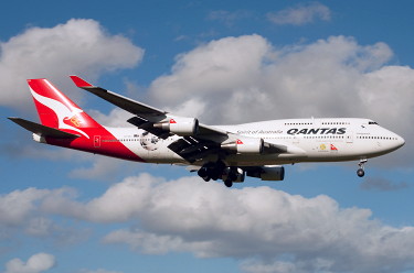
You tell me how QANTAS flies -- Non-Stop -- from Santiago Chile to Australia, when they DO NOT use the Airport in Chile?
"the longest non-stop scheduled airline flight is Qantas Flight (QF7/QF8) from Dallas-Fort Worth, USA - to - Sydney, Australia."
13,804 km (8,577 mi)
aussieairliners . org /b-747 /vh-oej
VH-OEJ. Boeing 747-438ER. c/n 32914-1331
Boeing 747-438ERs ordered new by Qantas - November 29, 2001
Rolled off the Boeing production line at Seattle (Everett) - June 06, 2003
Entered onto the Australian Aircraft Register as VH-OEJ - May 16, 2003
Registered to Qantas Airways Ltd, Sydney
First flown as N60668 - July 11, 2003
Ferried Seattle - New Iberia, Louisiana in all red livery without titles - July 31, 2003
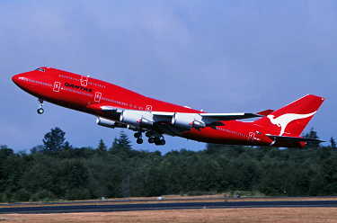
Painted into new 'Wunala Dreaming' livery

Ferried New Iberia - Los Angeles as QF6020 - August 15, 2003
Operated first revenue service Sydney - Los Angeles as QF107 - August 26, 2003
Registered to Qantas Airways Ltd, Sydney - May 11, 2005
Operated Melbourne - Singapore as QF6407 for unserviceable Jetstar service JQ7/JQ8 - August 11, 2011
Operated final service in 'Wunala Dreaming' livery Dallas - Brisbane - Sydney as QF7/QF8 - December 30, 2011
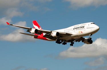
Returned to service in the corporate new livery Sydney - Dallas (Fort Worth) as QF7 - January 22, 2012
Current with Qantas
VH-OEJ. Qantas Spirit of Australia - in the standard livery at Sydney Airport, February 2015
Jul 12, 2015 7:35:28 GMT csp said:
Flights QF27 and QF28 are often serviced by VH-OEJ
I've looked into this before and the flights do indeed take ~14 hours - look at this, QF28
from Santiago to Sydney
I'd love for someone to go on one of these flights and record the entire flight from take off to landing, without interruption.
I still personally believe these are taking even longer than 14 hours, and certainly much longer than the advertised 12 hours on that Qantas page.
You tell me how QANTAS flies -- Non-Stop -- from Santiago Chile to Australia, when they DO NOT use the Airport in Chile?
"the longest non-stop scheduled airline flight is Qantas Flight (QF7/QF8) from Dallas-Fort Worth, USA - to - Sydney, Australia."
13,804 km (8,577 mi)
aussieairliners . org /b-747 /vh-oej
VH-OEJ. Boeing 747-438ER. c/n 32914-1331
Boeing 747-438ERs ordered new by Qantas - November 29, 2001
Rolled off the Boeing production line at Seattle (Everett) - June 06, 2003
Entered onto the Australian Aircraft Register as VH-OEJ - May 16, 2003
Registered to Qantas Airways Ltd, Sydney
First flown as N60668 - July 11, 2003
Ferried Seattle - New Iberia, Louisiana in all red livery without titles - July 31, 2003

Painted into new 'Wunala Dreaming' livery

Ferried New Iberia - Los Angeles as QF6020 - August 15, 2003
Operated first revenue service Sydney - Los Angeles as QF107 - August 26, 2003
Registered to Qantas Airways Ltd, Sydney - May 11, 2005
Operated Melbourne - Singapore as QF6407 for unserviceable Jetstar service JQ7/JQ8 - August 11, 2011
Operated final service in 'Wunala Dreaming' livery Dallas - Brisbane - Sydney as QF7/QF8 - December 30, 2011

Returned to service in the corporate new livery Sydney - Dallas (Fort Worth) as QF7 - January 22, 2012
Current with Qantas
VH-OEJ. Qantas Spirit of Australia - in the standard livery at Sydney Airport, February 2015


lizardking- Posts : 1673
Points : 7599
Reputation : 2604
Join date : 2015-12-30
Age : 31
Location : United Kingdom
 Re: Flight Routes, Shipping Routes, Under Sea Cables
Posted by csp on 07/12/2015
The only reason I pulled up the flight records from flight radar was to show the times aren't the same as advertised when selling the flight (and this is from ACTUAL DEPARTURE, to ACTUAL LANDING according to flight radar 24 data - which in reality should match the advertised time or close thereto).
As I stated in my first response - I do not believe these flights are actually happening and nearly ALL other bookable flights have stops and much longer flight times, again as I initially stated.
Thanks schpankme, so essentially this plane is meant to be flying QF7, but somehow flying QF27 according to FR24?
Looking at FR24, there is currently an A388 flying QF7, but it won't let me track the plane:
www.flightradar24.com/-0.12,-153.94/3
Date
2015-07-12
From To
Sydney (SYD) Dallas (DFW)
Aircraft
A388 (VH-OQH)
STD ATD STA Status
13:00 PM AEST 13:24 PM 13:35 PM CDT Estimated 13:08 PM
Can someone else try the link above?

lizardking- Posts : 1673
Points : 7599
Reputation : 2604
Join date : 2015-12-30
Age : 31
Location : United Kingdom
 Re: Flight Routes, Shipping Routes, Under Sea Cables
Posted by csp on 07/12/2015
And that site shows QF7 (which we've just discussed) and QF321 which goes via Auckland, and again, another flight I can't seem to be able to track via FR24:
www.flightradar24.com/-49.78,-112.84/4
According to google, it's on time and 4 hours out from Santiago.
EDIT: OK, you've cleaned him up
EDIT2: Might as well pop this here to, as some further evidence to lots of shenanigans with the QF321 flights in the past:
www.flyertalk.com/forum/qantas-frequent-flyer/1431924-qf321-survival-guide.html
Jul 12, 2015 10:37:59 GMT rayzor said:
Umm No, QF28 Departed Gate 16 at 14:30 SCL international for SYD on the 11/7/2015, they partner with LAN for other flights to RIO, LIMA, and SAO Paulo. (maybe others as well, not sure )
You can follow it up further on the FIDS system www.aeropuertosantiago.cl/english/flights-informations/index.php
And that site shows QF7 (which we've just discussed) and QF321 which goes via Auckland, and again, another flight I can't seem to be able to track via FR24:
www.flightradar24.com/-49.78,-112.84/4
According to google, it's on time and 4 hours out from Santiago.
EDIT: OK, you've cleaned him up

EDIT2: Might as well pop this here to, as some further evidence to lots of shenanigans with the QF321 flights in the past:
www.flyertalk.com/forum/qantas-frequent-flyer/1431924-qf321-survival-guide.html

lizardking- Posts : 1673
Points : 7599
Reputation : 2604
Join date : 2015-12-30
Age : 31
Location : United Kingdom
 Re: Flight Routes, Shipping Routes, Under Sea Cables
Posted by delta9 on 07/16/2015
International Space Station Orbit .. flight path
I was watching the ISS live feed of a live camera pointed down at Earth surface and they also have a live ground tracking orbit map. The ground tracking map shows the orbit of the ISS like a sine wave. I always wondered why satellites and spacecraft followed that weird wavy pattern instead of a straight line circle around the sphere. According to Google they have to draw it that way because the orbit path is not around the equator of the sphere but is more on an angled orbit path. So I took the Azimuthal Equidistant projection map and Photo Shopped a freehand circular orbit of their real-time live image and it works out pretty much the same as their claimed orbits of the thousands of satellites and every spacecraft orbit. The circular orbit path moves a little bit over on each orbit so a total coverage around the disc Earth model is looking kind of like a spiral, or a Slinky, around the magnetic North Pole.
Live ISS feed is here .. www.ustream.tv/channel/live-iss-stream


lizardking- Posts : 1673
Points : 7599
Reputation : 2604
Join date : 2015-12-30
Age : 31
Location : United Kingdom
Page 1 of 5 • 1, 2, 3, 4, 5 
IFERS - Exposing the 'Global' Conspiracy From Atlantis to Zion :: The International Flat Earth Research Society
Page 1 of 5
Permissions in this forum:
You cannot reply to topics in this forum
